
Article
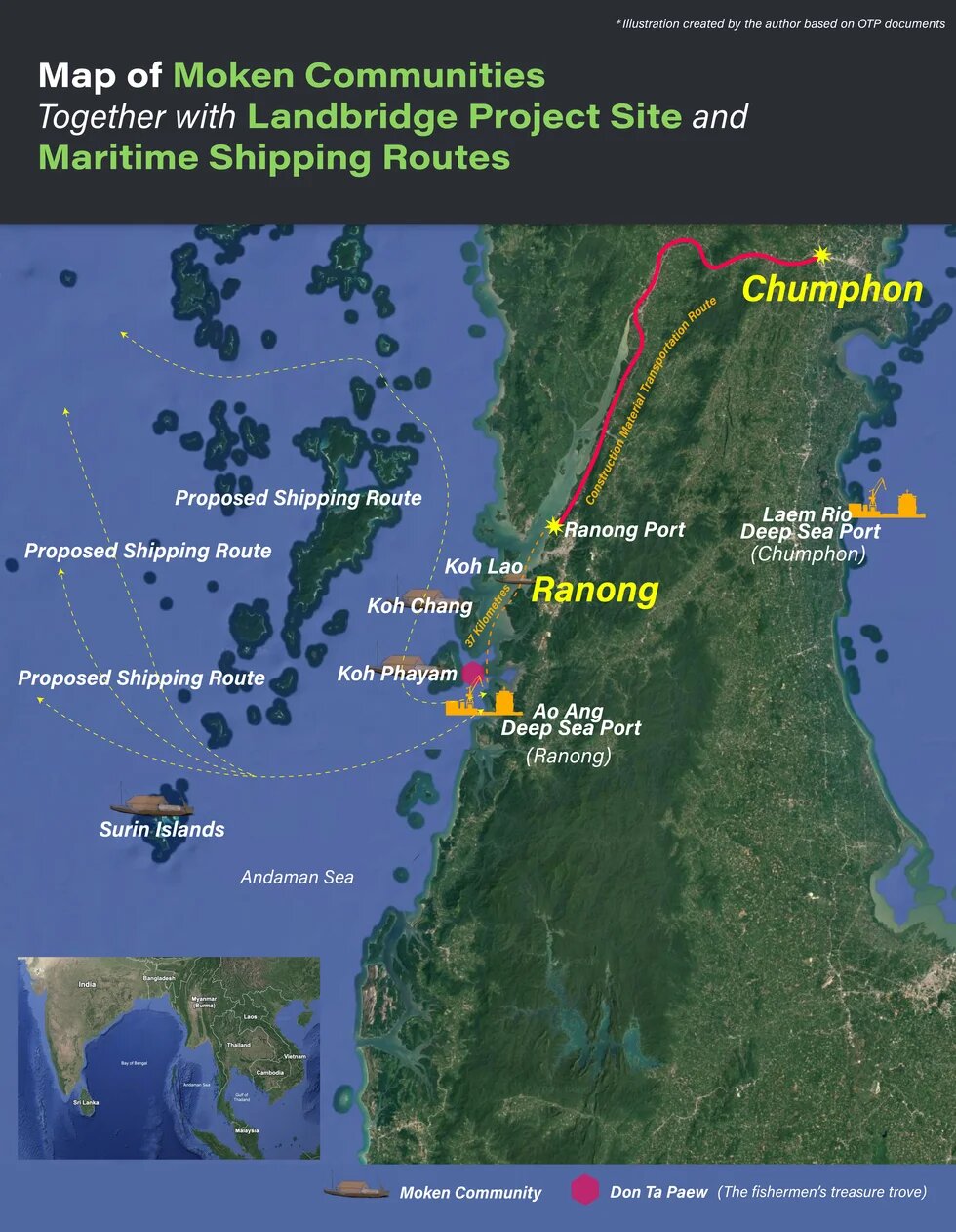
The Landbridge poses a serious threat to the Moken, whose Indigenous lifeways are deeply connected to the Andaman Sea. Their communities extend beyond Koh Phayam to Koh Lao and Koh Chang in Ranong, the Surin Islands in Phang Nga, and the waters where some continue to live at sea. Its impacts would therefore reach far beyond the proposed port site—from construction and material transport to future shipping routes—disrupting interconnected marine ecosystems and the Moken lifeworlds that depend on them across the Andaman Sea.

From the perspective of developers, discussions on the Ao Ang (Ranong Province)–Laem Rio (Chumphon) Landbridge under Thailand’s Southern Economic Corridor (SEC) have primarily focused on project feasibility, economic opportunities, and geopolitical advantages. Civil society actors, in contrast, have emphasized the limitations of public participation as well as concerns over potential social and environmental impacts. Yet the implications for the Moken remain marginal. Although the Landbridge will have direct and profound consequences for the Moken—an Indigenous people whose lifeworld is deeply intertwined with the sea—the structural constraints embedded within centralized development planning and impact assessment systems privilege technical procedures, thereby systematically excluding Indigenous maritime lifeways and knowledge from being recognized as legitimate rights-holders and meaningful inputs in development planning. Understanding this exclusion requires attention to the Moken’s lifeworld, in which the sea constitutes not only a material resource but also the primary spatial foundation of life.
Moken: Indigenous Peoples Living with the Sea1
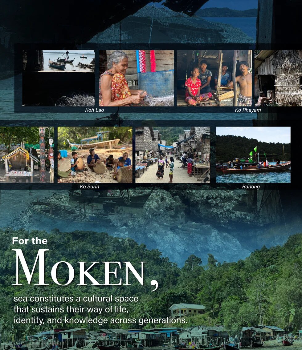
For the Moken, the sea is neither merely a source of food nor income; it constitutes a cultural space that sustains their way of life, identity, and knowledge, accumulated and transmitted across generations through an enduring relationship with the marine ecosystem. Historically, the Moken practiced seasonal mobility, adapting their resource use to the ecology of the Andaman Sea along both the Thai coast and the Mergui Archipelago of Myanmar.
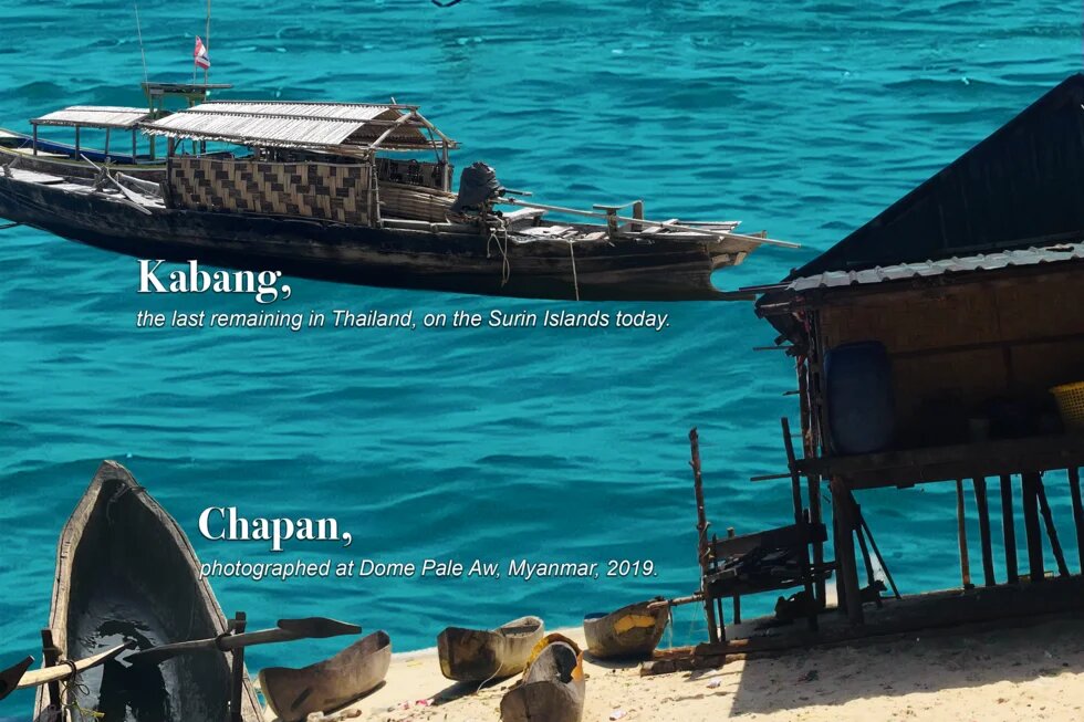
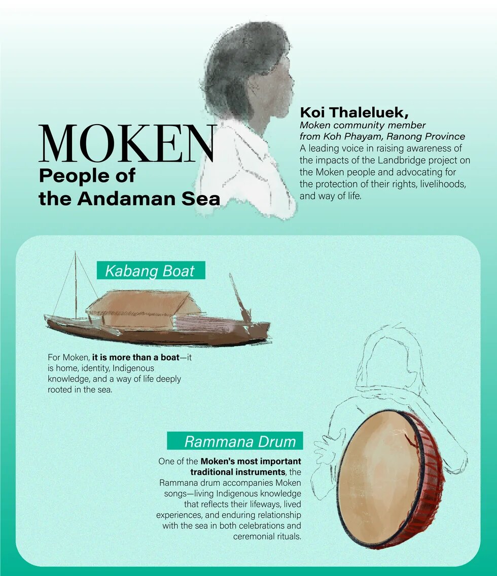
During the dry season, when sea conditions are calm, they lived aboard Kabang, a boat serving as both home and a means of mobility. During the monsoon season, they constructed temporary huts along coastal islands with sheltered bays and freshwater sources, while relying on forest resources such as yam, bamboo shoot, and wild plant for subsistence, medicinal purposes, and the repair of Kabang. They also used Chapan, a smaller rowing boat, to gather food along bays and island coastlines.
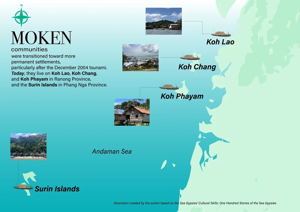
However, processes of state territorialization and the expansion of state authority over natural resources, conservation measurements, and tourism development—particularly after the December 2004 tsunami—have significantly transformed Moken lifeways in Thailand. The state has progressively reorganized Moken communities into permanent settlements, which today are located on Koh Lao, Koh Chang, and Koh Phayam in Ranong Province, as well as in the Surin Islands of Phang Nga Province.
Although settlement patterns and lifeways have changed under broader processes of territorialization through which the state regulates Indigenous mobility, spatial practices, and resource access, Moken lifeworlds cannot be reduced to island villages alone. As Moken commonly state, “Moken are born knowing how to swim before they walk.” Communities in Ranong Province continue to rely on fishing, nearshore shell harvesting, and shell diving, while also using bays and islands—such as areas between Ko Kham and Ko Phayam—as shelters from wind and waves and as overnight anchorages.
Meanwhile, Moken communities in the Surin Islands, although required to adapt to a tourism-based economy under state-managed conservation regimes, continue to rely on natural food sources during the monsoon and the tourist off-season. Moreover, they maintain socio-cultural practices connected to the Andaman Sea, including inter-island travel to visit kin and ritual practices such as funeral rites, Lo Boong ceremony regularly held on Ko Chang, and Chao Lay (Sea gypsies) kinship ceremony linking them with Moklen and Urak Lawoi communities across Phang Nga, Phuket, Krabi, Trang, and Satun Provinces.2
Structural Constraints of Landbridge Development Planning and Impact Assessment
The Andaman Sea constitutes the foundation of Moken life. The Landbridge project—through the construction of deep-sea ports and associated economic activities—therefore has profound implications for their livelihoods, cultural identity, and long-standing relationships with the marine environment. Therefore, in principle, development planning, feasibility studies, and Environmental and Health Impact Assessment (EHIA) should recognize Moken as stakeholders and co-producers of knowledge from the outset, ensuring that development accommodates Indigenous rights and lifeways.
The Landbridge project exemplifies a predetermined development trajectory rooted in the Southern Seaboard Development (SSB) master plan, approved by the Thai Cabinet in 1993. Despite persistent public opposition and spatial constraints, successive governments have continued advancing the project by repeatedly relocating proposed sites in search of politically feasible locations instead of undertaking a genuine reassessment of local capacities, ecological conditions, and community needs.
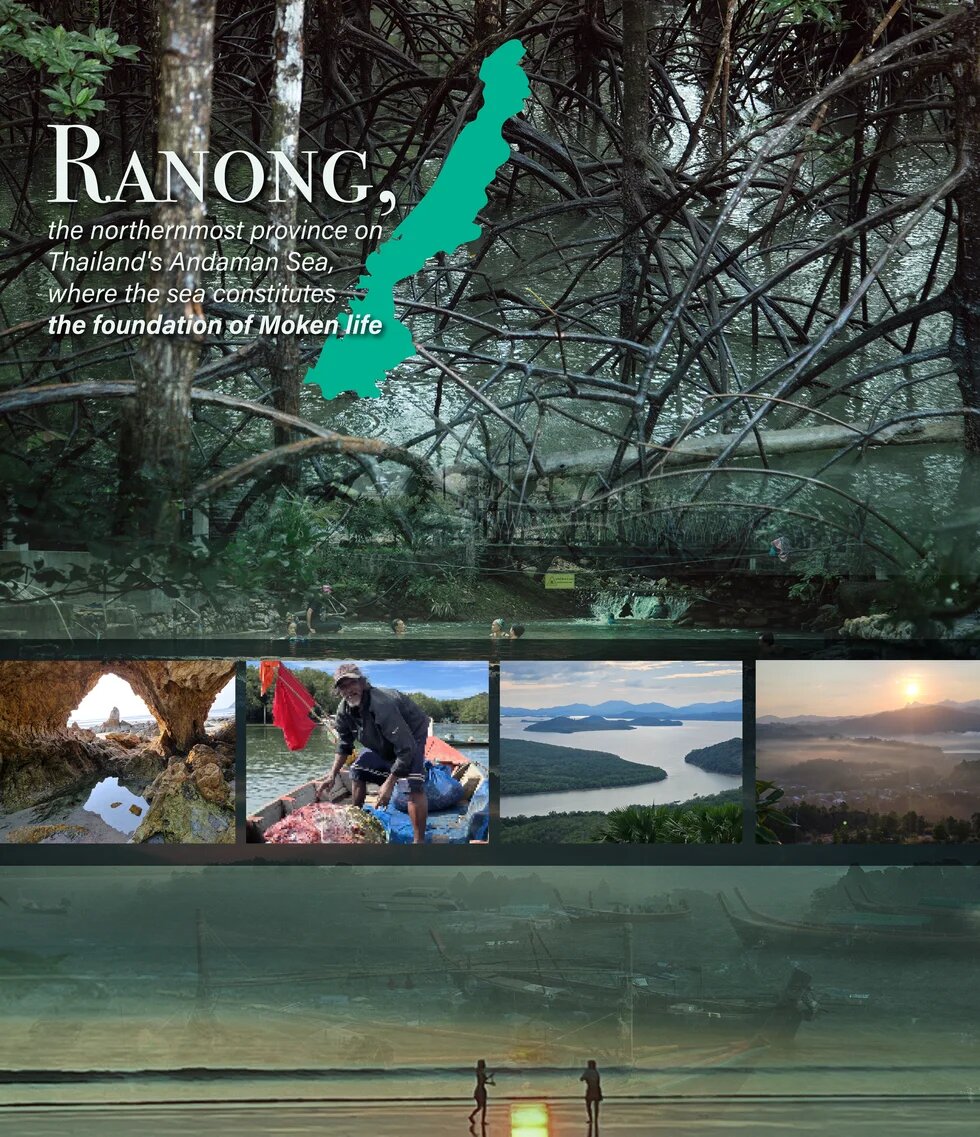
The Ao Ang (Ranong)–Laem Rio (Chumphon) Landbridge under the Southern Economic Corridor (SEC) clearly illustrates this logic. Although Ranong is characterized by a resource-based economy and ecologically fragile coastal ecosystems—including mangrove forests nominated for World Heritage status—it was designated as the Andaman deep-sea port site. This decision reflects not primarily the area's developmental suitability but rather the politics of territorialization, through which Ranong became a final fallback location after proposed sites elsewhere in southern Thailand had been repeatedly rejected through local opposition.
Once development policy is predetermined, local communities—and even provincial government agencies—are reduced to implementers rather than decision-makers. These structural constraints are also reflected in the EHIA process. The state predetermined the Landbridge project and its target areas before the EHIA began. Consequently, the assessment was designed primarily to identify mitigation measures rather than to evaluate whether the proposed development was appropriate for the area in the first place. Consequently, EHIA has been widely criticized as a ritualized process of symbolic legitimation that demonstrates compliance with legally required procedures, thereby conferring legitimacy on project implementation rather than serving as a genuine mechanism for protecting the public interest.
The structural limitations of the Ao Ang deep-sea port EHIA become even more apparent in the case of the Moken. Areas subject to impact assessment and public consultation are defined within a 3–5 km radius of the proposed port site, while stakeholder eligibility is based on fixed spatial boundaries and property-based criteria. Yet many Moken lack Thai citizenship, and their homes are often located on land occupied with the permission of private landowners and their settlements fall outside the designated impact assessment area, effectively excluding them from the consultation process despite being among the communities most directly affected by the project. This demonstrates that the core problem lies not in the presence or absence of EHIA, but in the narrow definition of legitimate stakeholders, grounded in fixed territorial boundaries and private property rights rather than culturally embedded patterns of marine resource use and Indigenous relationships with the sea.
The limitations of impact assessment are further evident in the project documentation, which indicates that stone will be sourced from Chumphon Province, while potential cement sources near the project area have been identified in Phetchaburi and Nakhon Si Thammarat Provinces3. These materials will be transported overland to the Ranong Multipurpose Port before being shipped by sea to the Ao Ang deep-sea port construction site. This maritime transport route passes through coastal waters and islands that constitute the living spaces and livelihoods of local communities, including the Moken settlement on Ko Lao; Ko Mho, which serves as a Moken ancestral burial site; the artisanal fisheries communities of Ban Hat Sai Dam and Ko Singhai; and Ko Chang, home to Moken community. Furthermore, once the port becomes operational, shipping routes will extend through the southern Andaman Sea toward the Surin Islands, an area renowned for its rich coral reef ecosystems and Moken communities in Phang Nga Province.4
The impact of the deep-sea port cannot therefore be confined to the 3–5 km radius. Rather, they generate cascading impacts across four interconnected zones: (1) construction material extraction sites, (2) overland and maritime transport routes, (3) the deep-sea port construction area, and (4) post-construction shipping routes once the port becomes operational. Together, these interconnected zones overlap extensively with Moken lifeworlds. Restricting impact assessment to the limited spatial boundaries defined by the EHIA framework therefore undermines principles of procedural justice by excluding affected communities from meaningful participation. It also exposes the limitations of Thailand's development process, which remain unable to accommodate Indigenous lifeways despite the enactment of the Ethnic Groups Protection and Promotion of Traditional Ways of Life Act, B.E. 2568 (2025).
Politics of Recognition and the Precarity of Moken in Ranong
The lived experiences of Moken in Ranong Province, including interviews published by The101.world5, reveal the persistent precarity of Moken rights to coastal habitation and access to marine resources. As Ju, a 52-year-old Moken woman, explained, ‘her community was formerly settled in another area of Ko Phayam but was relocated when the landowner developed the area for tourism. The same pattern had continued because coastal areas suitable for Moken lifeways have become increasingly valuable for tourism, while the extensive designation of protected areas has made finding new places to settle ever more difficult. Following the 2004 Indian Ocean tsunami, religious organizations assisted the community in acquiring land, leading to the establishment of the present-day Ao Khao Kwai Moken village. At the same time, restrictions on harvesting timber from protected forests to build Kabang—together with the gradual deterioration of the remaining Kabang, compelled many Moken to more settle permanently on land and adopt motorized boats. As a consequence, traditional boat-building knowledge and maritime lifeways have gradually declined.’
Ju's account reflects decades of adaptation and the gradual erosion of Moken maritime lifeworlds. For the Moken, the significance of the Landbridge extends far beyond mega-project development, representing a critical turning point that threatens the remaining foundations of their way of life. Although they are among the groups most directly affected, structural constraints within Thailand's centralized policy-making, together with the absence of meaningful recognition of Indigenous lifeways, have prevented Moken knowledge from being incorporated into development planning. While project developers conceptualize the sea through maps and technical indicators, the Moken understand it as a lived space, navigating through seasonal, stars, winds, and waves. These two knowledge systems remain largely disconnected. Consequently, Indigenous relationships with the sea, coast, and islands are not accorded meaningful value, and the project documentation provides no evidence of knowledge co-production with the Moken.
Given the state's structural barriers to participation, the Moken have never been meaningfully recognized by broader policy actors as participants in committees, parliamentary commissions, or other Landbridge-related policy-making bodies. Yet they have actively sought to make their voices heard rather than remaining passive recipients of development. They continuously engage with multiple channels to access information and communicate their concerns, including academics, NGOs, civil society networks, and the media. Because Moken lifeways are not grounded in notions of private property, they understand the sea as home and life. Their principal demand is therefore not compensation, but recognition as an Indigenous people with the right to shape the future of their marine homeland.
As Koi Thaleluek, a Moken community member, stated at a forum organized by Amnesty International Thailand6, many Moken still lack Thai citizenship and boat registration, meaning they are not formally recognized as rights-holders within the Thai bureaucratic system. As a result of development processes, they are among those most vulnerable, both in terms of spatial loss and the absence of legal protection. He further noted that while the state defines rights through documentary proof, the Moken have long inhabited both land and sea across generations without reliance on formal titles. Therefore, if the Landbridge project is implemented and it becomes impossible for the Moken to remain in their ancestral areas, the minimum requirement from the state should be the recognition and protection of their cultural practices, including permitting the harvesting of timber for building of Kabang. For the Moken, the Kabang is more than a boat; it embodies identity, knowledge, home, and a way of life deeply connected to the sea.
Conclusion
The challenges in the lives of the Moken reveal that the core problem in advancing the Landbridge project is rooted in structural constraints embedded in Thailand’s development and impact assessment process, which remain state-led in nature and have yet to meaningfully recognize Indigenous lifeways, knowledge, and rights as part of policy formulation and decision-making processes.
Although the Moken have lived in close relationship with the sea for generations, stakeholder definitions continue to be grounded in land-based ownership, fixed territorial boundaries, and technocratic knowledge. As a result, the sea—as both a cultural space and the foundation of Moken life—is not adequately incorporated into decision-making processes, despite the fact that port construction, material transport routes, and post-operation shipping lanes overlap significantly with areas where Moken communities have long sustained their livelihoods.
The Landbridge case further illustrates that the key limitation of development in Thailand lies beyond the presence or absence of EHIA, pointing instead to the lack of mechanisms that enable society to participate in setting development agendas from the outset. These include the absence of a legal framework for Strategic Environmental Assessment (SEA), as well as insufficient consideration of cumulative and cross-scalar impacts in large-scale or multi-component development projects.
Ultimately, as long as Thailand’s development planning remains a centralized process grounded primarily in technocratic knowledge and continues to exclude diverse ways of knowing—particularly those derived from local lifeways—it will struggle to achieve procedural justice that enables stakeholders to meaningfully participate in shaping the future of their territories.
___
Wipawadee Panyangnoi is an independent researcher holding a PhD in International Development from Chulalongkorn University. She has over 20 years of experience in human rights associated with development in particularly in Thailand with overaching geopolitical perspective at Southeast Asia regional and international levels.
Disclaimer: This published work was prepared with the support of the Heinrich Böll Stiftung. The views and analysis contained in the work are those of the author and do not necessarily represent the views of the foundation. The author is responsible for any liability claims against copyright breaches of graphics, photograph, images, audio, and text used.
Footnotes
- 1Arunotai, N. (Ed.). (2014). Sea Gypsies' cultural skills: One hundred stories of the Sea Gypsies. The Princess Maha Chakri Sirindhorn Anthropology Centre (Public Organization). [in Thai]
- 2The Moken, Moklen, and Urak Lawoi are Indigenous peoples of the Andaman Sea. Although they share many similarities in their maritime lifeways, each group has its own distinct identity. For instance, the Moken and Moklen share much of their vocabulary and are generally able to communicate with one another, whereas the Urak Lawoi language is considerably different. Their traditional boats also differ in design and can be readily distinguished. For further details, see Sea Gypsies' Cultural Skills: One Hundred Stories of the Sea Gypsies.
- 3Office of Transport and Traffic Policy and Planning (OTP). (2023). Ao Ang Cape Port Development Project, Mueang Ranong District, Ranong Province, under the Feasibility Study, Conceptual Design, Environmental Impact Assessment and Business Development Model Analysis for Transport Infrastructure Development under the Southern Economic Corridor Development for Transport Connectivity between the Gulf of Thailand and the Andaman Sea Project. Supporting document for the First Public Hearing, held on 16 August 2023 in Ranong. [in Thai]
- 4Office of Transport and Traffic Policy and Planning (OTP). (2023). Feasibility Study, Conceptual Design, Environmental Impact Assessment and Business Development Model Analysis for Transport Infrastructure Development under Southern Economic Corridor Development for Transport Connectivity between the Gulf of Thailand and the Andaman Sea Project. PowerPoint slides presented at the Meeting of the Ad Hoc Committee to Review the Landbridge Project Study, held on 15 December 2023 in Bangkok. [in Thai]
- 5Thanaloetsomboon, P. (2026, February). Moken: People on the margins of the sea, outside the Landbridge equation. The101.world. [in Thai], from มอแกน คนชาย (ขอบ) ทะเลนอกสมการแลนด์บริดจ์
- 6Amnesty International Thailand. (2025, December). From a Hidden Island to the Frontline of the Landbridge Struggle: Defending Housing Rights on Ko Phayam, Ranong. [in Thai], from จาก…เกาะลับสู่แนวหน้าสู้แลนด์บริดจ์ เพื่อสิทธิในที่อยู่อาศัย คนเกาะพยาม จ.ระนอง - แอมเนสตี้ อินเตอร์เนชั่นแนล ประเทศไทย


