
Article
Rather than viewing Thailand’s Landbridge as a transport infrastructure project, this article reinterprets it as a political process of territorial restructuring in Southern Thailand. Through the perspectives of geopolitical ecology and spatial justice, it shows how geopolitical imaginaries have been mobilized to legitimize industrial frontier expansion while redistributing environmental risks, marginalizing local knowledge, constraining meaningful public participation, and reshaping power relations between the state and local communities to secure new spaces for capital accumulation.

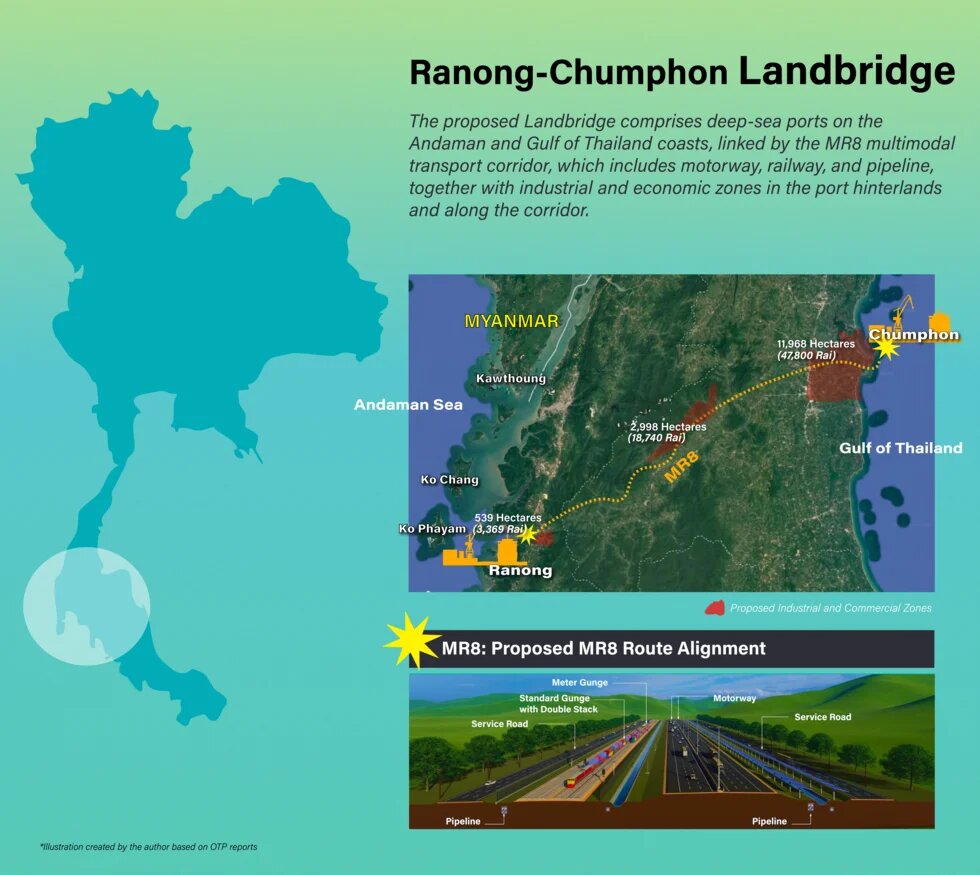
Thailand’s Southern Landbridge project is one of the country’s largest infrastructure-led development initiatives. The project comprises deep-sea ports on the Andaman Sea and the Gulf of Thailand, linked by an integrated multimodal transport corridor consisting of motorway, railway, and energy pipelines, together with industrial estates and commercial zones developed along the corridor.
Since the early 2020s, the Ao Ang (Ranong)–Laem Rio (Chumphon) Landbridge under the Southern Economic Corridor (SEC) has been promoted by the Thai government as a logistics corridor capable of strengthening Thailand’s competitiveness, providing an alternative transoceanic route that bypasses the Strait of Malacca, and positioning the country as a regional transportation hub. Yet studies1 commissioned by the project proponents themselves have questioned the commercial viability of the project as a corridor for transoceanic container transport. This raises an important question: why does the project continue to occupy a central position in Thailand’s development agenda despite persistent doubts regarding its economic competitiveness?
This article argues that the significance of the Landbridge lies not primarily in its logistical function but in its role as a mechanism for creating new economic spaces capable of accommodating industrial expansion, investment, and future capital accumulation. Drawing on the lens of geopolitical ecology, the article examines how state power, development discourse, and ecological transformation intersect in the production of new development frontiers in Southern Thailand.
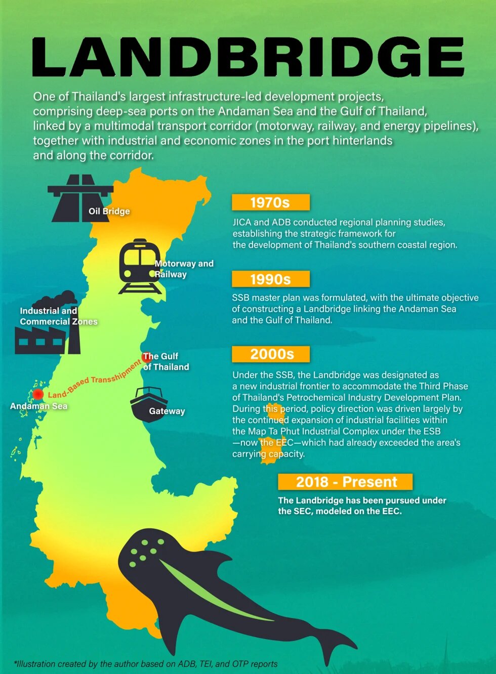
Southern Thailand was viewed as possessing several strategic advantages. It offered the potential to connect energy pipeline networks to natural gas resources in the Gulf of Thailand, while also providing suitable locations for deep-sea ports and sufficient land and raw water resources to support industrial development. Moreover, access to both the Gulf of Thailand and the Andaman Sea created opportunities to develop transportation corridors linking the movement of goods and energy between the two coasts. These considerations informed studies on southern regional development as early as the 1970s.
However, the Eastern region—particularly Chonburi, Rayong, and Chachoengsao—was geographically closer to Bangkok, the country's political and economic center. This locational advantage led the Thai state to prioritize these provinces as the core development area under the Eastern Seaboard Development Program (ESB), where they became the country's principal industrial production base under the First and Second Petrochemical Industry Development Plans (1980–2004). Meanwhile, the south, with the Landbridge concept at its core, was positioned as a future frontier for industrial expansion under the Third2 to Fourth3 Plans (2004–present)
The Landbridge strategy first emerged within the Southern Seaboard Development (SSB) framework during the early 1990s. Over the course of three decades, successive Landbridge proposals were repeatedly relocated and reformulated—from Krabi–Khanom and Thai Muang–Sichon to Pak Bara–Songkhla, and ultimately the current Ao Ang–Laem Rio under the SEC. Despite differences in location and design, studies conducted throughout this period reached remarkably similar conclusions. The project lacked sufficient commercial viability to attract large container vessels, which continue to favor uninterrupted maritime transport without cargo transshipment. Instead, the project's economic rationale consistently depended upon industrial development, with successive studies repeatedly identifying petroleum, petrochemical, energy, and related industries as essential to the project's economic viability.
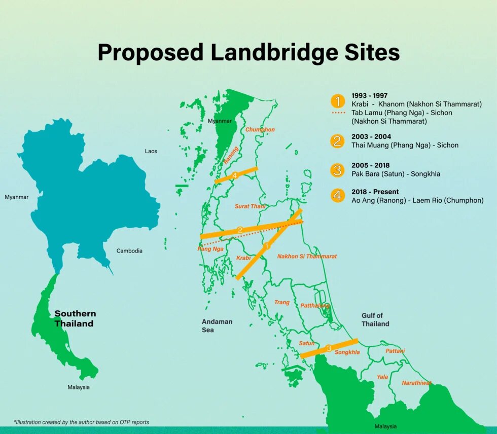
Viewed from this perspective, the repeated relocation of project sites reflected less an effort to improve transportation efficiency than a strategy of moving the project away from areas where earlier proposals had encountered strong local resistance while simultaneously searching for territories capable of accommodating industrial expansion beyond the Eastern region, particularly the Map Ta Phut Industrial Estate in Rayong Province, which has long served as Thailand's principal heavy industrial and petrochemical hub under Eastern Seaboard Development (ESB) and, subsequently, the Eastern Economic Corridor (EEC). This search unfolded in a context where carrying-capacity constraints, environmental conflicts, and resource pressures increasingly limited further industrial growth in eastern Thailand.
This development logic was clearly articulated in an Asian Development Bank-supported planning study for Southern Thailand in 20084, which stated:
“...The ability of Thailand’s Eastern Seaboard to accommodate additional industrial development is limited, primarily due to environmental concerns and infrastructure capacity constraints. As a result, there is increasing interest and pressure to plan for new industrial sites in Southern Thailand …”
Against this backdrop, the Landbridge represents a long-term strategy to extend industrial development frontiers from eastern to southern Thailand. Although contemporary government narratives emphasize logistics and connectivity, official studies have repeatedly indicated that the project’s economic viability depends upon the development of approximately 11,200 hectares (70,000 rai) of new economic zones designed to accommodate targeted New S-Curve industries. In this sense, the Landbridge reflects a broader process of re-territorialization through which places previously valued for fisheries, agriculture, tourism, and ecological conservation are redefined as strategic economic spaces for infrastructure and industrial development. Such transformation extends beyond physical changes in land use to encompass the reconfiguration of the social, economic, and political meanings attached to territory.
Ranong provides a particularly revealing case through which to examine these dynamics. Over the past decade, the province has increasingly developed a place-based economy centered on tourism, fisheries, agriculture, border trade, and environmental conservation. This trajectory has been supported by Ranong’s ecological assets, including high-quality hot springs, internationally significant mangrove and marine ecosystems that sustain extensive networks of local livelihoods and economic activities. These priorities are reflected in the Ranong Provincial Development Plan 2023–20275, which envisions “Ranong as a city of wellness tourism and high-value agriculture for improving quality of life.”
However, under the SEC framework, Ranong has been repositioned from a resource-based economy rooted in local livelihoods into the starting point of a large-scale industrial and logistics corridor determined through central government planning. The resulting conflict is therefore not simply about infrastructure development, but about competing visions concerning the future of place. These tensions became particularly visible during the Environmental and Health Impact Assessment (EHIA) process conducted between 2021 and 2026.
Although EHIA is formally presented as a mechanism for public participation and environmental governance, its implementation in the Landbridge case has been characterized by significant procedural limitations. Public consultations conducted during the COVID-19 pandemic relied heavily on hybrid and online formats that many local residents struggled to access. Although the pandemic subsequently subsided, these communication practices remained in place and gradually became normalized as standard procedures in the present, creating structural barriers that significantly constrained opportunities for local participation.
More importantly, the assessment process privileged technical expertise over local knowledge. Communities repeatedly challenged the narrow 3–5 kilometer impact boundary adopted by project consultants. The proposed Ao Ang deep-sea port site, locally known as “Don Ta Phaew” or “the fishermen’s treasure trove,” constitutes an important fishing ground and marine resource supporting coastal communities throughout Ranong. The area also contains ecotourism destinations, sacred Muslim sites, and marine territories closely associated with the Indigenous Moken.
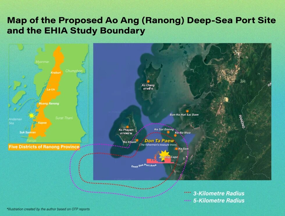
Yet these values were largely marginalized within official assessment documents. For example, the sacred mosque on Ko Son was identified only as an “unnamed mosque,” while the Moken were not recognized as an Indigenous people in project documentation. Likewise, consultant studies of benthic organisms reported the presence of only a limited number of species, despite community knowledge and marine scientific research indicating that the area forms part of a highly productive ecological system connected to the Ranong Biosphere Reserve, internationally important wetlands, and the wider Andaman Sea conservation area currently being proposed for inscription as a natural World Heritage site. Similarly, the draft EHIA released in 2024, which assessed the first phase of port development involving dredging and land reclamation approximately 1,806 hectare (11,287.5 rai), described the affected ecosystem primarily through technical references to polychaete species and characterized the environmental impact as the loss of benthic biomass that might affect marine food chains during dredging operations.
The determination of impact boundaries and the treatment of environmental and social impacts reveal the politics of knowledge embedded within the assessment process. Technical expertise produced by state agencies and consulting firms shapes what should be studied, what can be excluded, and which forms of knowledge are considered legitimate. In doing so, the assessment process reflects a broader discursive confrontation between local communities, who understand land and sea as place-based livelihoods constituted through ecological, economic, social, cultural, and spiritual relationships, and the state, which tends to conceptualize these spaces primarily as economic resources. Such representations detach ecological resources from the communities and cultural relationships that give them social meaning, while downplaying the long-term implications of irreversible ecological change and the restructuring of patterns of resource access and use upon which local livelihoods depend.
Another critical limitation is the absence of legal requirements for Strategic Environmental Assessment (SEA) in large-scale development planning. This enables fragmented assessments that prevent the public from understanding the systemic connections among project components. The Landbridge infrastructure package—including deep-sea ports, motorways, and railways—requires land expropriation, forest clearance, dredging, land reclamation, and the provision of raw water and electricity. Each component demands substantial natural resources and generates environmental impacts. Considered individually, these impacts may appear manageable. Viewed cumulatively, however, their combined consequences are extensive and far-reaching.
The persistence of the Landbridge despite recurring questions regarding its economic viability can also be understood through the concept of geopolitical imaginaries. For decades, the project has been framed through narratives of the ‘Western Gateway’, the ‘logistics hub’, and the ‘Indo-Pacific connectivity network’. These narratives portray Southern Thailand as a strategically important space connecting global trade routes and regional economies. Yet government-commissioned studies have repeatedly concluded that the project lacks the competitiveness necessary to challenge existing maritime routes because of higher transportation costs and longer transit times. More recent assessments have also suggested that the expansion of Belt and Road Initiative rail connections between China and Europe could further reduce the project's competitiveness.
In this context, the significance of the Landbridge lies less in its demonstrated logistical advantages than in the political work performed by these geopolitical narratives. Through them, the project is elevated from a domestic industrial development initiative into a matter of national strategy and international importance. This discursive framing is particularly significant because the environmental and health impacts associated with Map Ta Phut have become deeply embedded in Thailand’s public consciousness. Under such conditions, it is difficult to imagine that a project openly framed as a strategy for heavy industrial expansion could have remained politically viable for more than three decades. Presenting the Landbridge through the language of logistics, connectivity, and geopolitical strategy has therefore been crucial in broadening its political appeal and helping sustain its legitimacy despite persistent economic, environmental, and social criticism.
Ultimately, understanding the Landbridge requires moving beyond conventional analyses focused on transportation infrastructure or logistics competitiveness. Viewed through the lens of geopolitical ecology, the project emerges as a process of re-territorialization that brings together state power, capital, and development discourse in order to transform Southern Thailand into a new frontier of industrial development. The central issue is therefore not whether the project can compete with existing maritime routes. Rather, it concerns who possesses the authority to define the future of place and under what conditions local rights, knowledge, and ways of life can meaningfully shape development decisions. Southern Thailand is not a passive recipient of state planning but a political terrain in which development projects are continuously negotiated, contested, and reconfigured. The long-term viability of development cannot be secured through infrastructure construction alone. It rests on the state's ability to generate political legitimacy, advance spatial justice, and recognize diverse forms of knowledge as integral to the collective shaping of territorial futures.
__
Wipawadee Panyangnoi is an independent researcher holding a PhD in International Development from Chulalongkorn University. She has over 20 years of experience in human rights associated with development in particularly in Thailand with overaching geopolitical perspective at Southeast Asia regional and international levels.
Disclaimer: This published work was prepared with the support of the Heinrich Böll Stiftung. The views and analysis contained in the work are those of the author and do not necessarily represent the views of the foundation. The author is responsible for any liability claims against copyright breaches of graphics, photograph, images, audio, and text used.
Footnotes
- 1
* Office of Transport and Traffic Policy and Planning (OTP). (2023) Feasibility Study, Conceptual Design, Environmental Impact Assessment and Business Development Model Analysis for Transport Infrastructure Development under Southern Economic Corridor Development for Transport Connectivity between the Gulf of Thailand and the Andaman Sea Project (Progress Report 2). [in Thai], from รายงานความก้าวหน้า ฉบับที่ 2 (Progress Report 2) – โครงการพัฒนาโครงสร้างพื้นฐานด้านการคมนาคมขนส่ง; ** Office of Transport and Traffic Policy and Planning (OTP). (2025) Feasibility Study, Conceptual Design, Environmental Impact Assessment and Business Development Model Analysis for Transport Infrastructure Development under Southern Economic Corridor Development for Transport Connectivity between the Gulf of Thailand and the Andaman Sea Project (Final Report 2). [in Thai], from รายงานการศึกษาด้านการขนส่งและจราจร - สำนักงานนโยบายและแผนการขนส่งและจราจร (สนข.) กระทรวงคมนาคม
- 2 Bureekul, T. et al. (2009). Petrochemical Industry Master Plan, Phase III (2004–2018). The Thailand Environment Institute Foundation (TEI). [In Thai], from Microsoft Word - 00 ปกใน_150752.doc
- 3Office of the National Economic and Social Development Council (NESDC). (2564). Thailand's National Reform Plan (Revised Edition): Energy. [In Thai], from cr-improvement.pdf
- 4Asian Development Bank (ADB). (2008). Technical Assistance Completion Report: Planning for The Sustainable Development of Southern Thailand. From, Planning for the Sustainable Development of Southern Thailand
- 5Ranong Provincial Office. (2023). Ranong Provincial Development Plan 2023–2027. [In Thai], from 2023-04_6782852e28d1c32.pdf


