Article
A transboundary Kok River in Northern Thailand has been a source of livelihood of thousands in riverine communities. Recently, it has faced rising levels of heavy metal contamination, likely from suspected unregulated rare earth mining upstream in Myanmar. In response, the Thai government has proposed a billion-baht project to build sediment-trapping weirs or dams. While well-intentioned, this approach may not address the problem and could introduce new risks to both communities and ecosystem. This paper argues that meaningful community consultation and a comprehensive Environmental Impact Assessment (EIA) are necessary to ensure the project is transparent, effective, and truly benefits both people and nature.

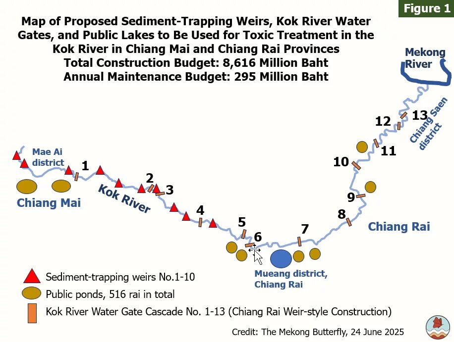
The contamination of heavy metals in the Kok River, transboundary river, has remained high since its initial detection in March 2025 and continues until the present. To address the issue, the Thai government proposed the construction of "sediment-trapping weirs" (or Gabion Check Dam[1]) as partially disclosed in the Project Proposal Document for the Construction of Sediment-trapping Weirs to Address Contamination Exceeding Standard Levels in the "Kok River" (Urgent Phase) by the Department of Water Resources. The construction project consists of three main components: sediment-trapping weirs, water gates, and water retention areas which will serve as a contamination treatment area by dredging public ponds. The project will stretch 120 kilometers from the headwaters of the Kok River in Mae Ai district, Chiang Mai, through the Mueang district town of Chiang Rai, and ending at the river mouth in Chiang Saen district. The total construction budget is 8,616 million baht with an annual maintenance budget of 295 million baht.
Despite the project's proposed budget of nearly ten billion baht, the proposal fails to provide sufficient information to demonstrate the effectiveness of the system in capturing and reducing heavy metal concentrations. This article will not address the issue of whether Thailand should be the sole entity responsible for funding this water remediation program. The Mekong Butterfly has created a map, as illustrated in Figure 1, to facilitate comprehension of the project's various components.
It is intriguing to observe that public forums or Environmental Impact Assessments (EIA) have not been mentioned by the Department of Water Resources. While each component of the project may not satisfy the criteria for conducting an EIA, the entire project, which has a budget of nearly ten billion baht, warrants a comprehensive evaluation of its economic benefits and effectiveness to prevent the spread of heavy metal contamination and further environmental impacts to other regions. Before advancing with the project's planning, the government must demonstrate its commitment by conducting a comprehensive environmental impact assessment (EIA) and ensuring a meaningful public involvement in the decision-making process. The Mekong Butterfly has identified several issues regarding each component of the project, as outlined below.
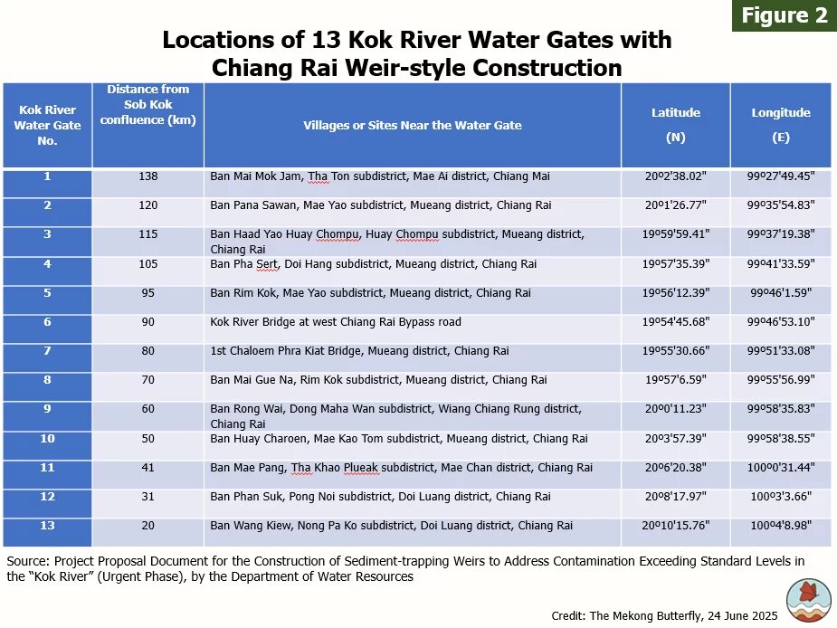
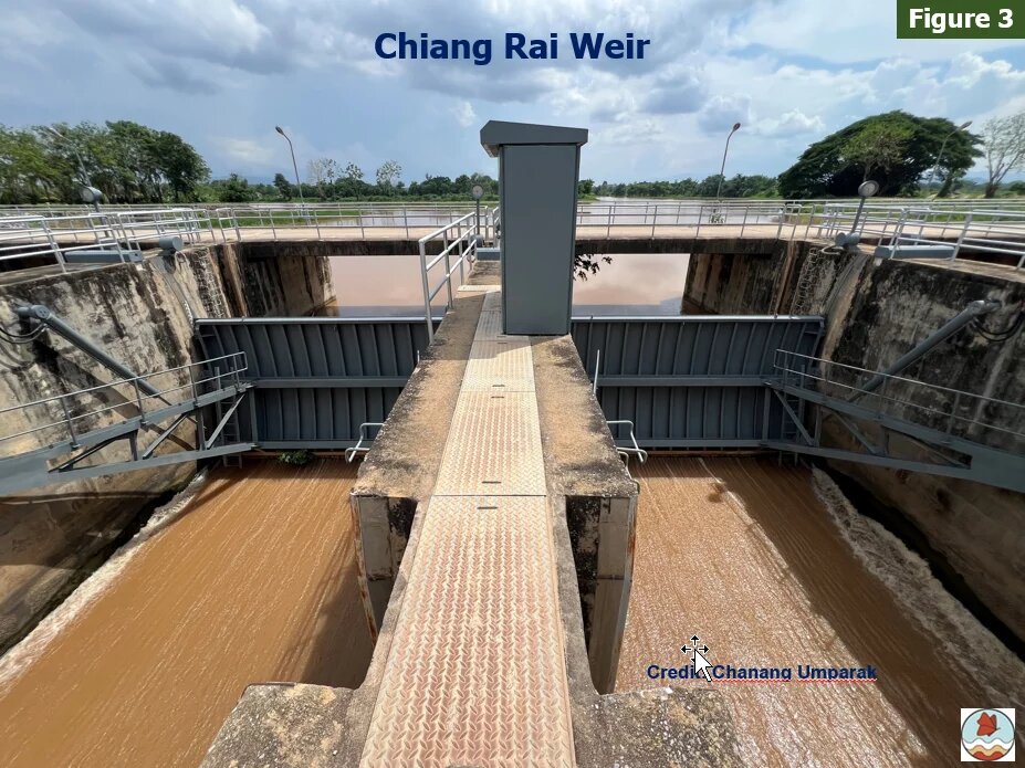
The first component involves the construction of water gates located on the Kok River (see Figures 2 and 3). Unlike the standard irrigation water gates introduced by the Department of Water Resources, these structures will feature large sluice gates and earth berms or dikes to control the speed of water flowing, replicating the design of the Chiang Rai weir. The sluice gates are intended to manage and slow the water flow, thereby enhancing the effectiveness of the Activated Carbon Wall and sedimentation processes for sediment capture. Additionally, the sluice gates also raise the water surface level to allow water to flow into the Kaem Ling (Monkey Cheek) water retention area. Without the water gates both the sediment-trapping weirs and the Kaem Ling water retention area would be unable to effectively remove toxic contaminants.
A cascade of thirteen water gates along the Kok River, extending from the Thailand-Myanmar border to the Mekong River, would transform Kok River into a reservoir. These barriers would disrupt the river's natural flow and pose serious risks to local communities and riverine ecosystems. The cracks that appeared on the flood walls of the Chiang Rai weir in August and September 2024 highlight what can go wrong. The breaches caused sudden flooding, resulting in significant losses and damages in many residential areas.
The flood walls of the thirteen planned water gates pose a serious risk, like a ticking time bomb, that could lead to the sudden inundation of adjacent communities, many of which are not adequately prepared. Water Gates No. 7-13, to be constructed between Chiang Rai's Mueang district and Chiang Saen district, are planned along a winding section of the Kok River, where the riverbed is almost flat. This could disrupt the river’s natural flow and slow down water drainage during floods. Another concern is whether this would subsequently increase the risks of prolonged flooding around the water gates.
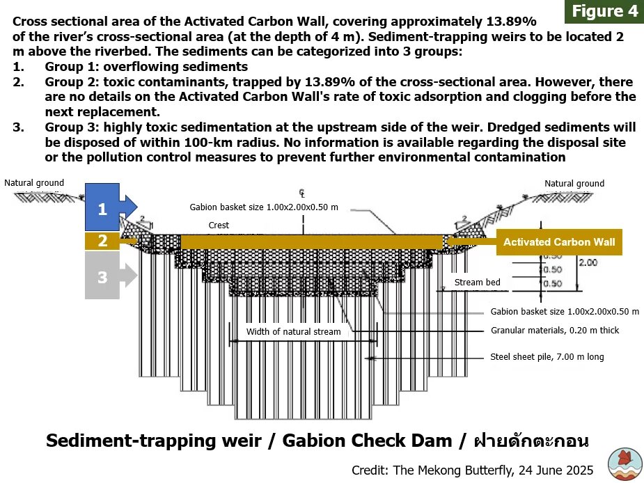
The second component involves the cascade of ten sediment-trapping weirs planned along the Kok River, starting from the Thailand-Myanmar border Chiang Rai's town (mueang) district (Figure 4). The project proposal shows the cross-sectional area of the Activated Carbon Wall which is approximately 13.89% of the river's cross-sectional area (at the depth of 4 meters). The sediment-trapping weirs will be located 2 meters above the riverbed. The sediments can be categorized into three groups:
Group 1: overflowing sediments
Group 2: toxic contaminants, trapped by 13.89% of the cross-sectional area. However, there are no details on the Activated Carbon Wall's rate of toxic absorption and clogging before the next replacement.
Group 3: highly toxic sedimentation at the upstream side of the weir. Dredged or removed sediments from the river will be disposed of within 100-km radius. But there are no details about the disposal location or how pollution will be prevented.
In spite the fact that the construction design will differ from the proposal document, there are no details or assessments about the project's effectiveness in terms of sediment control or heavy metal capture. Despite the potential risk that the sediment-trapping weirs could fail and release sediments with high levels of heavy metals downstream, information on prevention or cleanup is currently unavailable.
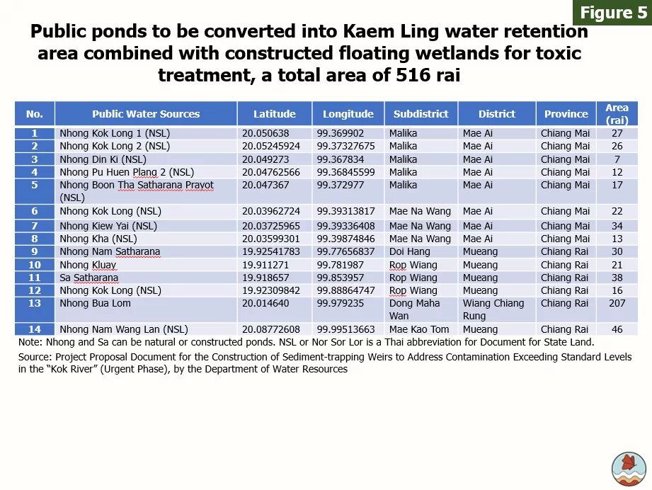
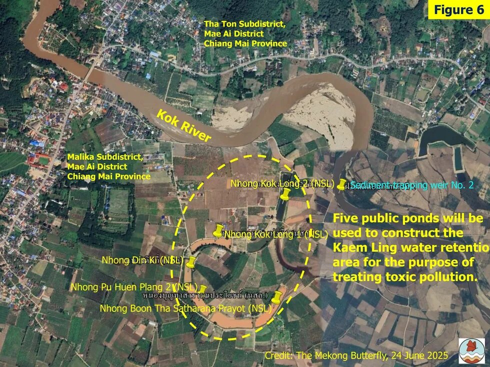
The third component is the 514-rai (82.24 hectares) Kaem Ling water retention area, created by dredging and converting public ponds or natural wetlands (Figures 5 and 6). The Kaem Ling will partially retain and restore contaminated water. Currently, there are two scenarios for dredging:
- Dredging 3 meters deep will provide in a total volume of 2,476,800 cubic meters.
- Dredging 6 meters deep will provide in a total volume of 4,953,600 cubic meters.
In 2024, the runoff volume of the Kok River, as recorded at the Khun Mengrai Bridge Hydrological Station (adjacent to Water Gate No. 5), was 3,498,555,456 cubic meters, excluding contributions from the Mae Lao River. In this case, if the Kaem Ling water retention area would be dredged to a depth of three meters, it is projected to treat 0.07% of the runoff volume recorded in 2024. If the depth of the dredging reached six meters, it is projected to treat 0.14% of the runoff volume recorded in 2024.
This raises several issues regarding the management of the Kaem Ling water retention areas:
- What are the current and historical uses of public ponds and Kaem Ling water retention areas? What are their ecological roles within the Kok River basin?
- What methods will be employed for dredging in each of the Kaem Ling water retention areas? What is the expected height of the flood walls?
- How long must water be retained in the Kaem Ling water retention areas necessary to allow effective phytoremediation prior to the discharge of treated water and the introduction of a new batch of water?
Dredged sediments will be disposed of within a 100-kilometer radius. No information is currently available regarding the disposal site or the pollution control measures to prevent further environmental contamination.
Heavy metal contamination in the Kok River calls for collaborative transboundary initiatives. Nevertheless, addressing this issue through an expensive construction project without meaningful public consultations with local communities and a completed comprehensive Environmental Impact Assessment (EIA) is unacceptable. Failure to uphold this commitment would make the Thai government appear complicit in worsening and spreading heavy metal pollution throughout the Kok River basin, harming the natural resources that local communities and the ecosystems deeply depend on.
Reference
[1] https://dwr.go.th/news_inside.php?news_id=127376 The Thai government notes that this weir is called "Gabion Check Dam" in English language.
___
The Mekong Butterfly is an independent group that has come together to carry on the spirit of protecting the natural resources, environment, ecosystems in the Mekong River Basin.
This article was first published in The Mekong Butterfly website.
Disclaimer: This published work was prepared with the support of the Heinrich Böll Stiftung. The views and analysis contained in the work are those of the author and do not necessarily represent the views of the foundation. The author is responsible for any liability claims against copyright breaches of graphics, photograph, images, audio, and text used.


