Article
It has been a decade since Typhoon Washi, known locally in the Philippines as Sendong, battered the city of Cagayan de Oro in the south and claimed more than a thousand lives in a single night. What have we learned since that time?

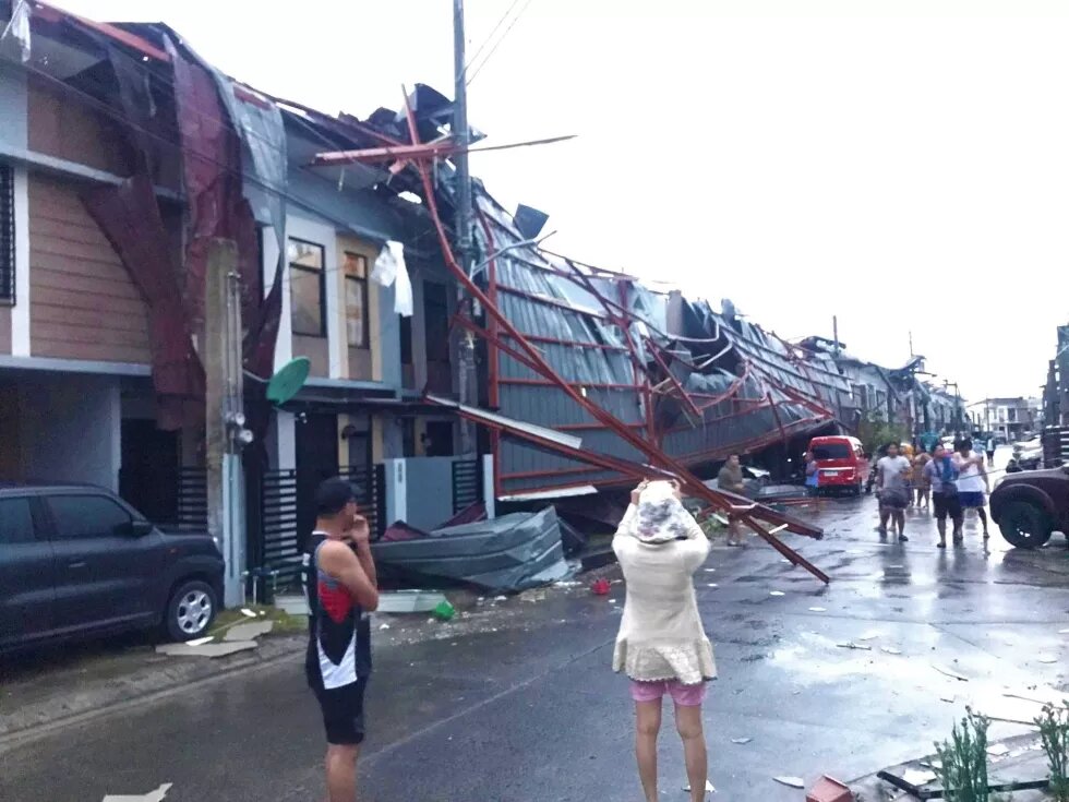
Tropical Cyclone Noru has recently battered Southeast Asia affecting about 940,000 individuals with USD 53.1 million worth of damages to agriculture and infrastructure and left 13 people dead. For the Philippines, Noru (local name Karding) was already the second major cyclone that hit the country in 2022. In April, Megi (local name Agaton) hit multiple regions of the country and left 214 people dead. Less than a year ago, Typhoon Rai, local name Odette, ravaged through central Philippines, leaving 407 people dead and more than USD 300 million worth of damages to infrastructure.
The increasing frequency and heightened intensity of tropical cyclones have been widely reported in recent years and is broadly attributed to anthropogenic climate change. As previously reported, the impact of increasing air and ocean temperatures and rising sea levels is already felt in Southeast Asia, with unprecedented flooding in major cities like Bangkok in 2011, Jakarta in 2018 and 2021, and various states in Malaysia in 2021. Because it lies in the so-called ‘typhoon belt’, the Philippines is one of the most typhoon-prone countries in the world with up to 20 typhoons hitting the country every year. With 60 million of its population living in cities, millions of Filipinos are more vulnerable to stronger typhoons. As Johanna Son noted for Southeast Asia, including the Philippines, “climate change and its impacts have been playing out in the present tense for some time, including through extreme, untypical weather events”.

Using the unprecedented flooding incident in my hometown of Cagayan de Oro in the southern Philippines as a case study, I present here the concept of disaster memory as a compelling mechanism in preparing for climate emergencies and extreme weather events like ‘superstorms’. When natural disasters occur, the focus of coverage usually centers on capital cities like Manila, Bangkok or Jakarta. This discussion therefore presents a post-disaster scenario in a secondary city in Southeast Asia, Cagayan de Oro, which lost more than 600 of its citizens to Typhoon Washi in 2011.
My research experience deals with social memories on state-sponsored violence. Filipinos, and perhaps the world, would know about the 1986 People Power Revolution that toppled the Marcos dictatorship, which would be rightly classified as a human rights disaster that claimed thousands of lives. When the first Marcos regime ended, efforts were made to memorialize this dark period in movies, museums, monuments and numerous markers. Yet, all of these did not prevent the return of the Marcos family to power in 2022. Despite the potential of memorials to become potent reminders and an effective source of lessons for history, a more pressing problem is arising – the climate emergency and extreme weather events.

Sendong, the catastrophe we did not expect
Typhoon Washi, local name Sendong, ravaged through the southern Philippines, hitting the major cities of Cagayan de Oro and Iligan at midnight on 16 December 2011 until the early hours of the next day. On exactly the same day 10 years later in 2021, the same areas were hit by the stronger Super Typhoon Rai, known locally as Odette. While it may have left Cagayan de Oro and Iligan largely unscathed with zero casualties, Odette is a reminder of how dangerous natural disasters can be and that they will be coming back more often. Sendong only had maximum sustained winds of 95 kilometers per hour (km/h), weaker compared to Odette’s 195 km/h, yet the death toll for Sendong was by the thousands. Most of the deaths were recorded in communities adjacent to the Cagayan River, the river traversing across Cagayan de Oro.

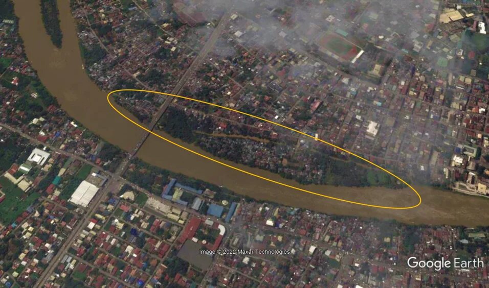
Before 2011, a vibrant community was located along the river, including the areas marked as former river channels (in yellow outline in the photo above, now covered by other structures). During the tenure of Mayor Vicente Emano (now deceased), houses made of light materials were allowed to proliferate in these areas because its residents were known to be his vote-rich base. After Sendong, areas adjacent to the river were finally declared ‘no-build zones’ and households were then moved to resettlement sites in various parts of the city. Two years later, in the 2013 local elections, Emano lost his bid for a fifth term as mayor and his loss was directly correlated to the impact of the typhoon in the city.
Today, a decade since, much of the evidence of the Sendong disaster is barely visible, and Cagayan de Oro has changed physically and politically. The subtle visual memories of Sendong are seen in the urban spaces of Cagayan de Oro, and these memories reflect what the local government and residents learned from the natural disaster.

Concreted memories of Sendong
This section tells the story of the events that transpired at midnight 16 December 2011, as told by the concrete memorials built to commemorate Sendong. At the heart of the city, right across the city’s cathedral, a memorial wall was erected, etched with the names of the victims and with the following inscriptions:
“Earth has no sorrow that Heaven cannot heal”
“In memory of those who perished during the rampage of TS Sendong in Cagayan de Oro last December 17, 2011”
Upon closer inspection, the majority of names etched in the wall share the same surnames. Together with the inscription describing Sendong as a ‘rampage’, this memorial provides the haunting details of how victims died that night: families were fast asleep when the floodwaters rampaged through their house.
Cagayan de Oro had long been unaccustomed to strong typhoons. In fact, the storm signal for Sendong was merely Signal No. 2, which did not prompt the local government to carry out evacuations. And so in the early morning of 17 December, the catastrophic effect of Sendong was laid bare: a total of 1,268 people died, many of them women and children on the path of the typhoon. Most of the deaths were reported in Cagayan de Oro (674) and Iligan (490). More than 6,000 persons were injured. What happened was that rain waters increased the height of Cagayan River from its normal level of 2 meters to 10 meters. Floodwaters flowed at high speeds carrying large debris from the watershed, such as logs, boulders and mud, and struck at everything and anything that crossed its path.
The death count above does not account for the 181 victims whose bodies were never found. With its location just across the city’s cathedral, this memorial wall poignantly serves as the tombstone for the victims whose bodies were not recovered and the site where survivors pay respects to their family members who died.
The second memorial is dedicated to a mango tree which is located in Isla de Oro, an islet located in the middle of Cagayan River. The tree is said to have saved at least 50 people during Sendong as the inscription says:
“THE TREE OF LIFE: This mango tree saved more than 50 people, residents of Isla de Oro, at the height of the unprecedented flooding caused by Tropical Storm Sendong last December 16, 2011.”
The inscription serves as an account of how people survived the rush of flood waters during Sendong. With their houses swept by the flood, more than 50 people had to cling to the mango tree to save their lives. Compared to their houses, in the islet, the mango tree is firmly rooted on the ground and stood higher than the flood waters. Looking at the height of the mango tree from the picture below, we can only imagine how high the flood waters went up.

Both Sendong markers presented here are built in public sites which are meant to be visited by survivors, residents and all who want to pay tribute, facilitating the usual purpose of memorials as symbols of the past that is shared by the community. However, the design for use and the inscriptions of these memorials are limited to the purpose of being mere reminders and do not serve any educative purpose or warnings about disaster preparedness. This makes it likely for the two markers to fall into ineffectiveness, much like the martial law memorials, in preventing a repeat of the catastrophe.
Isla de Oro: the island swallowed by the flood
Memories of disasters, and their lessons, are not only built into concrete memorials, they also come in the form of abandoned spaces. The tree of life described earlier is located in Isla de Oro, a swath of land in the middle of Cagayan River. Using images from Google Earth, this section tells the story of the island that tricked the urban poor into believing it was their haven in a bustling city and what happened to the community they built when Sendong came.
The photo below shows Isla de Oro on June 2011, six months before Sendong. Beyond the cloudy skies, the structures littered all over the small islet are visible. During this time, up to 500 families or an estimated 7,000 people, were living in the area. When Sendong came, the majority of these structures were wiped out as the entire islet was swallowed by flood waters, with news later that 44 residents had died.
One might ask, how did a spot in the middle of the river came to be called home by thousands of people? And after Sendong, what does its present state tell us about what the city and its former residents learned from the disaster?
Like many cities, Cagayan de Oro started out as a settlement that grew along the river. However, as decades passed and the population grew, the surrounding areas of the riverbanks became cramped with houses and establishments and could no longer accommodate any more settlers. This is when the swath of land across the river, eventually called Isla de Oro, became an attractive site to build a life for new settlers. What its early settlers chose to dismiss was that Isla de Oro was merely a patch of land that occasionally emerged when water receded at low tide in the river.
During the tenure of Mayor Emano, a socialized housing program granted land titles to households, like those in Isla de Oro, that could not afford the costs of relocation because their livelihood was in the city center. These policies were deemed to have encouraged the urban poor, whose houses were made of light materials to dwell in risky areas without further assistance to them to better manage inherent risks.
In the aftermath of Sendong, it was revealed that the Philippine Department of Environment and Natural Resources (DENR) through its Mines and Geosciences Bureau (MGB) delivered warnings to city officials twice that year of “possible adverse effects of the La Niña weather phenomenon, including sudden floods in the wake of strong storms”. These warnings were apparently ignored and on the eve of 16 December 2011, Sendong came for the residents of Isla de Oro.
An aerial view of Isla de Oro in March 2018 shows the islet above ‘surface level’ of Cagayan River. Only this time, instead of houses littered all over the area, the islet is filled with some sort of greenery, even if multiple scientific papers describe it as a mere sand bar. In just seven years, Isla de Oro looks to have replenished itself with vegetation and healthy plant life, making it appear starkly different from its surrounding area. It is the only green patch of land that is empty of any built structures in the middle of the city. However, the emptiness of Isla de Oro does not mean that it has been completely rejected by its former inhabitants.

Following Sendong, the local government prohibited survivors to return to their communities, specifically in the river’s delta. Then Philippine president Benigno Aquino declared these areas permanently “no-build zones”. However, relocation sites for the survivors were built in areas physically distant from the city center. Many of them worked in the informal sector as market vendors and rickshaw drivers, livelihoods which required them to reside at or near the city center. Many of its former inhabitants attempted to return to Isla de Oro and rebuild their lives there after Sendong. It would take a strict mandate from the national government and a change in mayor to finally prevent re-settlement in the area. Local ordinances passed during the term of Oscar Moreno, the mayor who replaced Emano, imposed severe punishment such as monetary penalty and imprisonment, to those violating the no-build policy. This is why Isla de Oro, despite its prime location at the center of the city, remains empty today.
Lessons from history, if we’re listening
While the local government recognized and made efforts to memorialize Sendong in its history, it would take stricter policies to instill among its residents the lessons from the natural disaster. Sustainable post-disaster recovery requires learning from the painful past to prevent recreating a similar catastrophe.
Climate scientists have already raised the alarm that global warming will only make storms stronger in the future, threatening the large and growing coastal populations in Asia. The latest Intergovernmental Panel on Climate Change (IPCC) report also warned that “global warming, heavy precipitation and associated flooding are projected to intensify and be more frequent in most regions in Africa and Asia”, which means that natural catastrophes brought by storms like Washi (Sendong), Haiyan (Yolanda) and Rai (Odette) are not likely to end within our lifetime. As painful as it is, these grim warnings should urge us to look back and learn from the past.
__
Gretchen Abuso teaches in the Department of Sociology and Anthropology at Xavier University in the Philippines. Now undertaking a PhD in sociology at the University of the Philippines, she is also a member of the Working Group Transformation of Environment of the COST Action project Slow Memory.
The views expressed in this publication are not necessarily those of Heinrich-Böll-Stiftung.


