Article
Cambodia’s Indigenous Land Titling (ICLT) is a government-led program to protect indigenous communities’ land and livelihoods. However, its internal contradictions result in the fragmentation of indigenous land management practices.

Keurn, a 70-year-old indigenous Jarai farmer living in Tangse village in northeast Cambodia’s Ratanakiri province, was sitting in anger for days. He was angry at being restrained by the village’s Communal Land Titling Committee from clearing the edge of his land where he grows cashews and upland rice.
Keurn, who had moved to the current village site about 20 years ago, follows the Jarai way of semi-subsistence rotational swidden cultivation. He grows upland rice and cashews on his 2.5 hectares of land that he cleared himself. Using land for farming has been a natural way of life for him and his ancestors. When land productivity began to decrease or if disasters occurred, the community would move to clear new areas following the decision of the village elders and build their new homes.
“I do not understand why I should not clear this land. They [the ICLT committee and NGO] told me the ICLT benefits me. But now I regret joining it. Please tell me if this is a really good thing for me.”
Keurn’s concerns seem justified, given that ever since the ICLT started, the process has been mired in internal contradictions and land zoning uncertainties, resulting in increased competition over the management of fields and forests traditionally used by the indigenous communities.
In 2001, the Government of Cambodia enacted a new land law that recognizes indigenous peoples in Cambodia as a legal entity. It was followed by a sub-degree (SCG 2009) to enable the implementation of the indigenous Communal Land Titles (ICLTs) to allow indigenous communities to protect their lands and maintain their rotational swidden cultivation. In Ratanakiri Province, notorious for land-grabbing and indigenous land dispossession, state officials have now awarded ICLTs to 44 villages (or are in the final land titling process).
Since the early 2000s, Tangse village has undergone a series of conflicts due to escalating competition over land. The region’s fertile red soil and abundant resources were soon eyed for economic development by agribusiness companies and government agencies. Two economic land concessions and one mining concession claimed considerable land that the community farms and uses. In addition, some influential individuals claimed and purchased land that the community had used.
Over the past decade, this increasing economic competition over land and forest compelled the Tangse community to obtain Indigenous Communal Land Titles. The community thought that the ICLT would help them better protect their farmlands and forest areas, given that encroachment into their lands had become a severe issue threatening their livelihoods.
Tangse village registered over 3,000 hectares of land through the ICLT in a comparatively short time. In this process, many community members were asked by the community leaders to get their lands measured and register them as “communal land.” But it was clear that most of the community did not understand the concept and process of the ICLT.
Like many of his neighbors, following the majority’s decision without a clear understanding of the consequences, Keurn put all 2.5 hectares of the land he was using under the ICLTs program giving the community shared ownership.
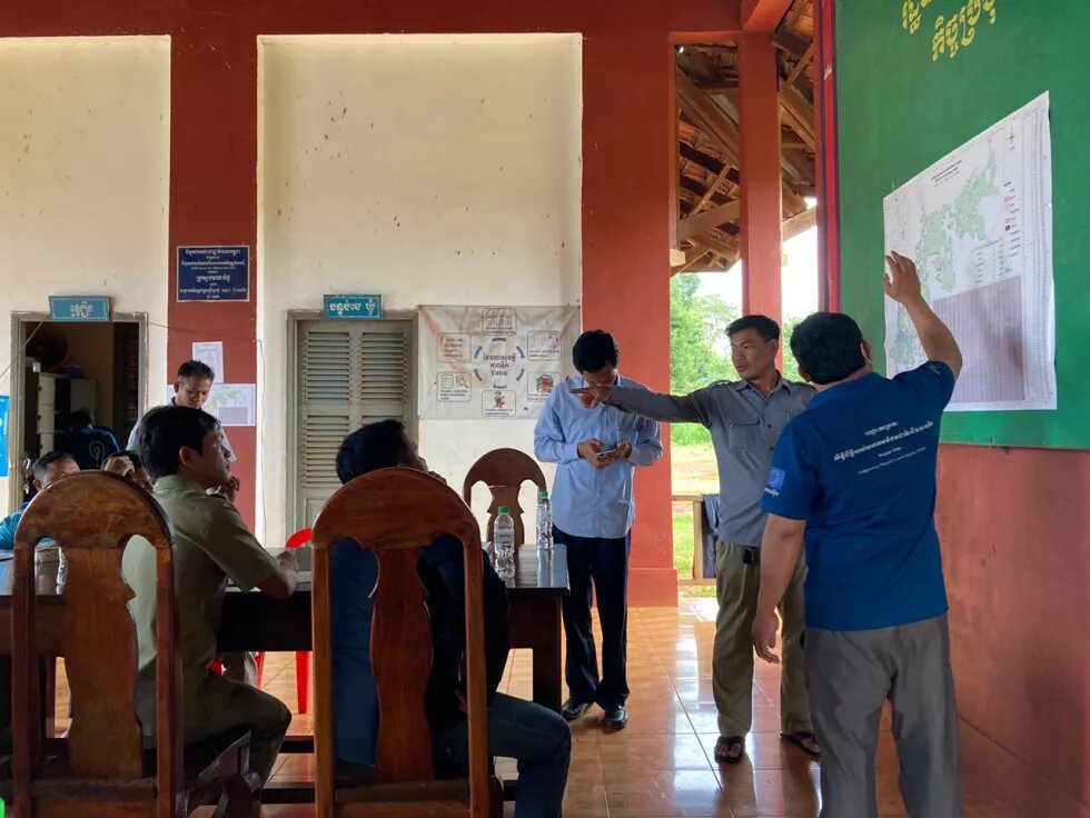
Meeting of the ICLT of Tangse village held in Nhang commune hall, Andoung Meas district of Ratanakiri province in October 2022. A GPS specialist from the Provincial Department of the Ministry of Land Management, Urban Planning and Construction (MoL) is explaining the ICLT map. (Photo by Eunbi Ko.)
ICLT’s problems lie in its legal clauses that primarily view indigenous land and people as a “subject” to be governed rather than a cooperative undertaking. While the ICLTs are an effective tool to claim land rights for some indigenous communities in Cambodia, for the most part, the program has led to the state imposing more regulations over the ‘marginalized land and population’ to make them more ‘legible.’
This is illustrated in the categorization of land by the ICLT. In the titling process, all lands coming under the ICLT are classified under five categories: residential land, farming land, reserved farming land, burial forest, and spiritual forest, according to their functions. All claims must be presented with proper evidence and require accurate boundaries for GPS measurements. In the titling process, each individual is asked to measure the edge of their farming and residential land, but the titles are issued on the entire land under the community’s name. ICLT’s process has translated the customary communal management system into mixed ownership rights using a state-led legislative land classification process.
“It has to do with the way the state governs the land being used by indigenous people,” said Vat Naron, a legal expert and project coordinator of a local NGO supporting the ICLT for the past decade. “For example, during the communal land titling process, the size of each indigenous village’s burial forests and spiritual forests is limited to up to seven hectares by law, regardless of the size of the villages. This is because, unlike residential areas, the community can request larger pieces of forest land without physical evidence. The government does not want to ‘lose’ more forest land that can be leased to businesses.”
Since the original purpose of the ICLT was to support indigenous farming livelihoods based on rotational swidden cultivation, the lands registered through the ICLT also come with a series of constraints over their use.
For example, the land needs to be managed by the community and cannot be sold to outsiders nor collateralized for loans. This places indigenous people’s land outside of the domestic and international economy by ‘protecting’ them against the opportunities and challenges of the market. Although, on the face of it, this seems an excellent way to protect these lands, however, it does not ensure indigenous people’s existing way of farming and livelihoods.
Many indigenous activists point out that the way ICLT views land is fundamentally different from the way the indigenous communities view and use the land. Many indigenous communities’ understanding of the land is closely linked to their customary way of perceiving space. The land is much more than a mere usable object subject to a lease or sale; the use of land is often accompanied by customary knowledge and spatial taboos and spirits. In other words, the perception of land and their livelihood space in the indigenous communities in northeast Cambodia tends to be far from a dividable or bondable object that can be neatly divided into state-imposed categories.
“ICLT does not fit the actual understanding and use of space in the indigenous villages,” said Sompoy Chansophea, an ethnic Kreung working for the Cambodian Indigenous Peoples’ Organization. “It divides the land and classifies it. It tries to define where the boundaries are, but the way we understand and use space is more flexible than that.”

ICLTs can, and have, functioned as a valuable tool for protecting the land of the indigenous communities in Cambodia, particularly for those communities at risk of big and small land grabbing. However, internal contradictions drive more communities and community members to leave the ICLTs.
“The new way of land management has changed many things,” said a member of the ICLT Committee of Katieng Village, an Indigenous Brao village that obtained the ICLTs last year, who spoke on condition of anonymity. “Now we have to buy land rather than clearing it, pay a fine if our livestock crosses the fence of our neighborhood. Also, the area of our burial forest will soon become full. I believe in the ICLT, but it still could be improved,” he said.
__
This article first published by Mekong Commons on 05 May 2023, as part of the output of "Mekong Commons Online Writeshop" supported by Heinrich-Böll-Stiftung Southeast Asia regional office.

Eunbi Ko is a Ph.D. candidate in geography. Her research examines the uneven management and dispossession of land in the resource frontiers by reviewing the governance of indigenous territories in northeast Cambodia.
The views expressed in this article are not necessarily those of Heinrich Böll Stiftung.
