

The island of Penang, on the northwestern coast of Peninsular Malaysia has a very hilly topography. Almost 50% of land is hilly, and 39% is classified as Class III and above, having slopes more than 25⁰ in gradient [1]. Underlain mainly by weathered granitic bedrock, this rugged topography has been a bane for development, as it presents a myriad of engineering and environmental challenges. Weathered granitic bedrock is vulnerable to land sliding and soil in areas like Paya Terubong (In the central part of the island) show high susceptibility to deep landslides [2]. The National Slope Master Plan 2009-2023 identifies Penang island as a landslide prone area [3].
With these dangers clearly understood, as well as the role of hill land as green lungs and water catchments, the Penang state implements the strictest laws on hill slope development in the nation. The Penang Structure Plan 2020 (PSP 2020), the state's planning blueprint until 2020, prohibits development on land above 76 metres above sea level (m a.s.l.) and/or exceeding 25⁰ in inclination.
However rapid urbanization on the eastern coast and an acute shortage of flat land on the island, has resulted in development creeping up hill slopes. In 2015, a revelation by the state executive councillor (now Chief Minister) YB Chow Kon Yeow revealed that a staggering 56 projects on slopes above 76 m a.s.l. or with gradients above 25 degrees were approved between 2008 and 2015 [4]. In April 2016, the Penang Hill Land Working Committee, found more than 100 hectares of hill land were cleared on the Penang Hill, some of which were illegal [5].
What is fueling this rampant hill slope development and how is it impacting people's lives in Penang Island? This article seeks to explore these questions and look at what's the best way forward.
Why is hill development in Penang intensifying?
The primary reason for this lies in the fact that that the Penang State Government's development centric policies allow for it. The State Government, helmed by the Democratic Action Party (DAP) which came to power in 2008 has had a firm foothold in the state ever since, with a significant amount of support coming from the island. Local Government and Housing Development Committee Chairman, Jagdeep Singh Deo, stressed that the state government will continue building on hill slopes which are below 76 m a.s.l. as long as they meet all safety regulations, citing the shortage of land as a reason why hill development projects need to continue [6]. The Penang Chief Minister, YAB Chow Kon Yeow insists that stopping hill slope development would not benefit the state, taking the example of Hong Kong which builds on the steepest slopes without fuss, and thus Penang should follow. Analyzing the current trend of development in the state, a significant portion of future and ongoing development are for new roads and highways, which are permitted under the 'Infrastructure' clause in the state's hill land regulations. The ongoing Paya Terubong Paired Road (PTPR), the upcoming North Coast Paired Road (NCPR) and the Penang Island Link 1 (PIL1) are just a few examples.
While the state is adamant that hill land development continues and assures that Penang's strict hill slope development guidelines will restrict wanton destruction and prevent catastrophes, members of Penang's vocal civil society groups are not convinced with these assurances especially in light of the multiple natural disasters which have struck the island over the last 5 years. Dr Lim Mah Hui, a Penang Forum Steering Committee member and a former Councillor in the Penang Island City Council (MBPP) concurs that the pressure to develop hill land originates from the fact that hill land is much cheaper than flat land. This allows developers to build residential units at significantly cheaper prices than if it were on flat land. And since Penang lacks a local plan, which plays a significant role in regulating planning and density control, guidelines are easily tampered with.

Dr Kam Suan Pheng, a GIS expert and biologist who is also a Penang Forum Steering Committee member points to the fact that the PSP 2020's guidelines provide a legal provision that allows hill land development for ‘Special Projects’. Loose interpretation of the term 'Special Project’ which were intended for projects of public interest like public infrastructure, has allowed for even high-rise private development to get approved under the guise of ‘Special Project’. An example is the Sunway Hills project in the Sungai Ara in the southeast of the island. The land which was previously gazetted as hill land with about 43% of slopes exceeding 25⁰ in gradient and above 76 m, was purchased by a property developer. The developer put forth a proposal to construct high-rise apartments and bungalows on the plot. In 2012, the MBPP approved the development under PSP 2020's ‘Special Project' clause. Concerned Sungai Ara residents filed an appeal to the Penang Appeals Board but conflicting interpretations of the term coupled with a lack of a local plan has resulted in the case dragging for 7 years without a conclusive end in sight.
Dr Kam Suan Pheng also points to the fact that developers tend to circumvent restrictions on development by getting approval for housing development on natural slopes lower than the stipulated threshold after which they cut into the neighboring slopes to increase flat land, resulting in man-made slopes that are steeper than 25⁰. An example is the Granito development in Tanjung Bungah where the original 18⁰ slope was cut back to a 67⁰ slope that was not stable. Construction began right against this slope, resulting in a landslide which killed 11, that has now come to be known as the 2017 Tanjung Bungah landslide.
Having strict guidelines comes hand in hand with proper enforcement. In 2015 alone, 68 cases of illegal hill clearing were detected as well as numerous instances of non-compliance to proper mitigation works. All these point to the fact that monitoring and enforcement are sorely lacking in the state. The Penang State Executive Councillor for Public Works, Utilities and Flood Mitigation, YB Zairil Khir Johari admits to this, hinting that the large hill range in Penang island makes it impossible to monitor every inch.
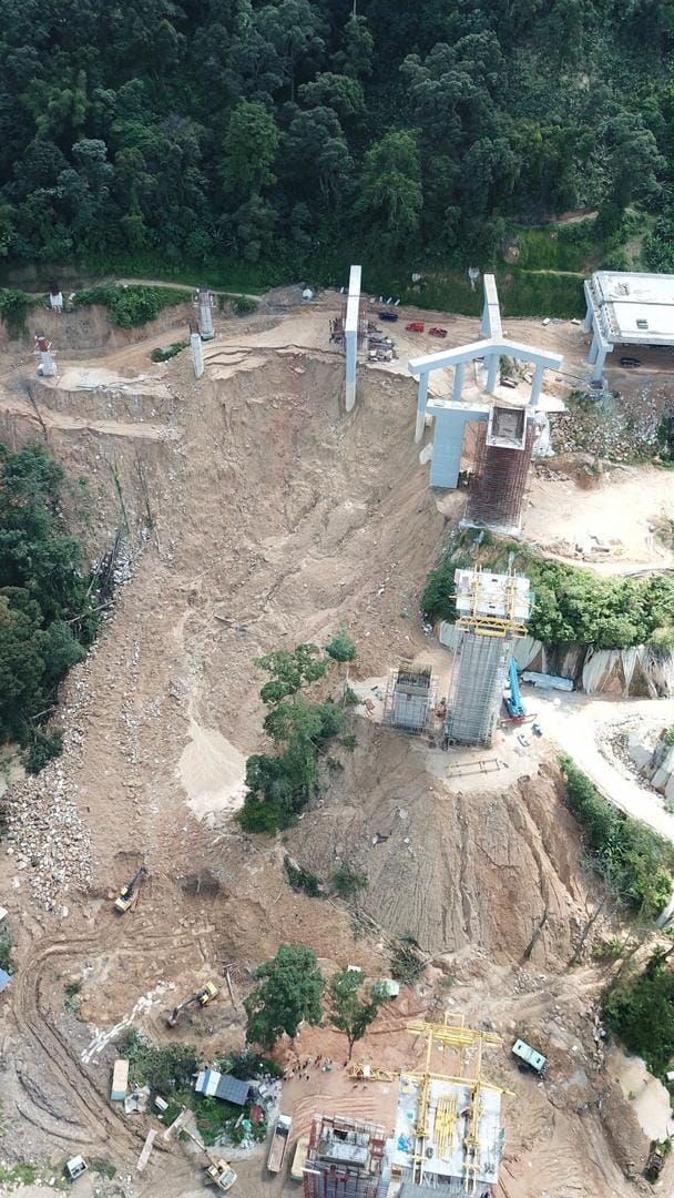
Ever more worrying is scale of non-compliance to Erosion and Sedimentation Control Plans (ESCP) by developers. After the 2018 Bukit Kukus landslide, it was revealed that not a single construction project in Penang State observed proper soil erosion mitigation plans [7]. A clear example of this case was that of the PTPR. In late 2017, following complaints from residents, the Penang Island City Council (MBPP) directed the developer of the project to work on strengthening the terraced hill slope, building check dams, installing geotextile sheets and planting grass on the cut portions [8]. However, a year later when a joint task force checked on the site, many of the same irregularities were found; check dams and sediment ponds which were not in compliance with the ESCP as well as portions of topsoil not planted with grass and open slopes that were not covered by geotextile sheets. In 2019, large areas of the project remained exposed without grass and geotextile sheets showing that despite repeated warnings from the monitoring exercises, no substantial mitigation work was done by the developers. It is a problem which the state recognizes and which was highlighted by the state enquiry into the 2018 Bukit Kukus landslide. As Dr Lim Mah Hui points out, MBPP's Geotechnical unit, which is in charge of monitoring hill slopes is understaffed and weak, lacking the professional and technical capacity to carry out proper monitoring of hill land in the island.
Paltry fines and light action taken against responsible parties also do not serve as deterrents in preventing future incidents of illegal hill clearing. In 2013, the land owners of Bukit Relau (Relau Hill), General Accomplishment Sdn Bhd were slapped with a RM 30,000 fine (later raised to RM 50,000) for illegally clearing a football field sized portion on the hill top and told to take special mitigation steps. The paltry fine was quickly settled, however to this day, a large portion of the hill still remains bare and untreated. The 2017 Tanjung Bungah landslide also had a similar fate, with the main contractor of the project being fined RM 35,000 for failing to ensure the site was risk free. Dr Lim Mah Hui relates that these paltry penalties only embolden developers, as it sends the signal that cases of hill clearing constitute a minor offence. YB Zairil sees a lacking on the side of laws that can be enforced, pointing to the fact that there needs to be by-laws to impose hefty compounds and fines on errand developers.

How is rampant hill land development impacting people's lives?
The most obvious impacts of hill land development in Penang are the increasing intensity of floods and landslides.
Mageswari Sangaralingam from Friends of the Earth Malaysia (SAM) explains that as vegetation is removed from hill slopes for development, slopes are exposed to surface erosion which in turn results in sedimentation of drainage systems that lead to flash floods. Construction work on hilly areas also exposes the core rock, making them susceptible to landslides.
In 2015, residents in Taman Sri Rambai and Taman Lau Geok Swee, two residential areas in Paya Terubong who live near a hill slope development project started complaining that whenever it rained, soil gets washed down from the development site onto their roads and into the Sungai Dondang (Dondang River) flood water retention pond just downstream [9]. The muddy waters result in reduced water storage capacity, and when this happens, it overflows into Jalan Paya Terubong, the main artery road, contributing to the persistent flooding menace in the area.
The worst floods in Penang's recent memory was in November 2017, when a large part of the island was flooded, displacing 7400 people and resulting in 7 deaths. Though there were multiple reasons which caused this flood, hill slope clearing for development aggravated drainage and resulted in the largely muddy floods as well as the numerous incidences of landslips and sink holes in construction sites around the island.

The November 2017 flood came at a heavy economic toll, resulting in losses up to RM 300 million to industry players, mostly small medium enterprises (SMEs) [10]. The poor were hard hit too, with some in riverside villages losing almost everything, as the muddy flood waters swept away their belongings and their livelihoods.
What was more deadly than the floods were the two fatal incidents of landslides in hill site construction areas. While there were multiple incidents of landslides across the island in the past, two of these, the 2017 Tanjung Bungah landslide and 2018 Bukit Kukus landslide, stand out, as they were both fatal, resulting in the deaths of 20 people, a figure which is unprecedented in Penang's recent history. Such deadly mishaps, have left a physiological impact for many residents living nearby. For residents near hill slopes in Tanjung Bungah, this fear of natural disasters, pushed them to urge the state 'to halt every hill slope project until a proper study is done' [11]. In the aftermath of the 2018 Bukit Kukus landslide, residents living close to the site started getting worried each time it rained with some considering relocation if they had an opportunity [12].

Conclusion
The myriad impacts hill development has brought about in Penang reinforces the need to relook at hill slope development in a more holistic manner through the lenses of stronger environmental governance.
In dealing with floods and landslides, the focus should be centered on flood and landslide prevention, which calls for proper land use planning and stringent controls on development on slopes.
The role of a local plan is important in preventing haphazard development from happening and thus the state should make every effort to expedite the implementation of a local plan in Penang. There also needs to be an emphasis in diffusing development out of land strapped Penang island, into the vast mainland part of Penang State, which is primarily flat and poses less geotechnical challenges to develop.
Poor monitoring and enforcement, which is hampering the duties of the local council in spotting cases of non-compliance, needs to be rectified. As Penang keeps looking at Hong Kong as a prime example, a key takeaway from the city state that we should emulate is to have large teams of geotechnical experts and engineers assigned to specific slopes. They must be made accountable for its safety. Use of technology like drones should be wholeheartedly embraced to make monitoring more comprehensive. Unless and until the state is ready to stringently monitor and enforce laws and guidelines in regards to hill slope development, they should not liberally approve projects on slopes as they do so currently.
While incidents of landslides and floods have often resulted in a war of words between civil society and the government over the state's hill slope development policy, it is important for the state to take into account the grouses of these independent voices and engage them proactively as they are able to give valuable input in working towards a solution.
The Penang 2030 vision which was unveiled by the Chief Minister in 2018 clearly outlines the need to work towards a clean and green Penang, where there is a well kept balance between economic growth and ecological protection. As the impact of climate change is being manifested in Penang through increasingly higher rainfall, it is time for the state government to move away from policies and projects which prioritize economic growth over environmental concerns, and rethink the development models which we have followed thus far, in line with this vision.
References
[1] Safety Guidelines for Hillsite Development 2012 <http://www.mbpp.gov.my/sites/default/files/penangsafety1409.pdf>
[2] Characterization and Geotechnical Properties of Penang Residual Soils with Emphasis on Landslides, American Journal of Environmental Sciences 2 (4): 121-128, 2006 ISSN 1553-345X © 2006 Science Publications, https://thescipub.com/pdf/10.3844/ajessp.2006.121.128
[3] National Slope Master Plan 2009-2023, Cawangan Kejuruteraan Cerun, Jabatan Kerja Raya Malaysia, http://jpedia.jkr.gov.my/images/d/d3/National_Slope_Master_Plan_2009-2020_-_Versi_English.pdf
[4] "Penang approved 56 hill slope projects since 2008, says exco", Malay Mail. 17 November 2015, https://www.malaymail.com/news/malaysia/2015/11/17/penang-approved-56-hill-slope-projects-since-2008-says-exco/1006465
[5] "100ha cleared on Penang hill range, confirms state report.", Free Malaysia Today. 25 April 2016, https://www.freemalaysiatoday.com/category/nation/2016/04/25/100ha-cleared-on-penang-hill-range-confirms-state-report/
[6] "Citing land shortage, Penang exco says hill slope developments will go on", Malay Mail. 13 November 2018, https://www.malaymail.com/news/malaysia/2018/11/13/citing-land-shortage-penang-exco-says-hill-slope-developments-will-go-on/1692888
[7] "Erosion mitigation plans ignored", The Star. 20 October 2018, https://www.thestar.com.my/news/nation/2018/10/20/erosion-mitigation-plans-ignored-checks-show-projects-did-not-follow-sop/#AS3pA5L1UeVubrvA.99
[8] Cleared portion of Bukit Kukus safe, says Penang mayor. Free Malaysia Today. 22 November 2017, https://www.freemalaysiatoday.com/category/nation/2017/11/22/cleared-portion-of-bukit-kukus-safe-says-penang-mayor/
[9] "Residents to stage protest", The Star. 31 October 2015, https://www.thestar.com.my/metro/community/2015/10/31/residents-to-stage-protest-hillslope-project-washing-down-mud-and-debris-claims-group/#FT2TCqFikdMy0lAm
[10] 1000 companies lose RM300mil to Penang floods, The Star. 10 November 2017, https://www.thestar.com.my/business/business-news/2017/11/10/1000-companies-lose-rm300mil-to-penang-floods/
[11] Penang residents call for halt on hillside developments, New Strait Times. 8 November 2017. https://www.nst.com.my/news/nation/2017/11/300859/penang-residents-call-halt-hillside-developments
[12] Apartment dwellers live in fear, The Star. 4 December 2018, https://www.thestar.com.my/news/nation/2018/12/04/apartment-dwellers-live-in-fear-residents-worry-about-slope-stability-after-hills-cleared-for-develo/
Abbreviations and honorific titles
A.S.L- Above Sea Level
YB- Yang Berhormat (Honorific title for politicians)
YAB- Yang Amat Berhormat (Honorific title for politicians)